Portsmouth’s geology changes fast. Over on Portsea Island you hit soft alluvial clays and silts from the old harbour basin, but move north towards Portsdown Hill and the chalk marl is barely a metre down with flint gravel mixed in. A standard borehole log tells you part of the story, but without a full grain size analysis — sieves for the coarse fraction plus a hydrometer for the fines — you are guessing at the actual behaviour of the formation. We run the full BS 1377-2 suite because a project on Commercial Road needs a different grading envelope than one up on the chalk ridge. Understanding whether that "sandy clay" is actually a gap-graded silt with trace gravel changes the drainage design, the compaction spec, and the bearing capacity calculation. Our lab in the Solent region processes hundreds of samples a year from basement digs, highway widening on the M27 corridor, and coastal defence works along Southsea seafront.
If you don't measure the full curve from 63 mm down to 2 microns, you don't know whether the soil will drain in a week or a year.
Process overview
Local context
Portsmouth’s position — a flat island between Langstone and Portsmouth Harbours — means the water table sits barely a metre below ground across much of the city centre. When the grain size analysis reveals a gap-graded silt with a clay fraction above 15 percent, capillary rise can keep the formation nearly saturated year-round. That turns a routine basement dig into a dewatering headache if the contractor assumed a free-draining sand from the borehole description alone. The marine alluvium along the M275 corridor also carries variable salt content; we wash samples before the hydrometer run when conductivity is high because flocculation of clays in saline water gives falsely coarse readings. On the chalk slopes north of Cosham, a grading curve that shows a steep drop at the 20-mm fraction often signals solution-widened joints and a risk of sudden water ingress during piling — the particle-size distribution is your first line of evidence for karstic features before you ever run a resistivity line.
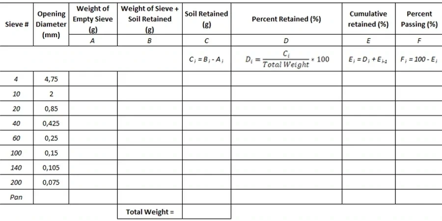
Visual overview
Reference standards
BS 1377-2:1990 — Classification tests, BS 5930:2015+A1:2020 — Code of practice for ground investigations, BS EN ISO 17892-4:2016 — Determination of particle size distribution, Eurocode 7 (BS EN 1997-2:2007) — Ground investigation and testing
Additional services
Combined Sieve & Hydrometer
Full curve from 63 mm cobbles down to 2-micron clay, with D10, D30, D60, uniformity and curvature coefficients calculated. Suitable for earthworks specification, drainage design, and soil classification to BS 5930.
Atterberg Limits Correlation
We recommend pairing the hydrometer result with liquid and plastic limit tests on the same sample. The combined data gives you the plasticity index and the activity ratio, which is far more useful for predicting swell potential than the grading curve alone.
Pre-Treatment & Salt Washing
For samples from Portsmouth's tidal flats and dock basins, we run conductivity checks and wash out salts before sedimentation. Organic-rich estuarine clays get a hydrogen peroxide pre-treatment so the hydrometer reads the mineral fraction correctly.
Typical parameters
Quick answers
What's the difference between a sieve analysis and a full particle-size distribution?
A sieve analysis stops at the 63-micron sieve and gives you the coarse fraction only. A full particle-size distribution adds the hydrometer sedimentation test to quantify the silt and clay fractions below 63 microns, which is essential for classifying fine-grained soils under BS 5930.
How much sample do you need for a combined sieve and hydrometer test?
We need roughly 500 grams of dry material for a standard combined test, though we prefer a 1-kg bag to allow for moisture content determination and a repeat run if the first hydrometer curve looks unusual.
Do you test chalk-rich soils from the Portsdown Hill area?
Yes, we handle the chalk marl and flinty gravels common on the dip slope. We run the sieve stack with care on the chalk fraction because crushing during shaking can skew the grading — our lab often checks the retained material under a hand lens to confirm whether the fines are genuine matrix or abraded chalk dust.
What standard do you report to?
We report to BS 1377-2:1990 for the test procedures and classify the soil to BS 5930:2015+A1:2020. If the project follows Eurocode 7 we also include the relevant BS EN ISO 17892-4 nomenclature.
What does a grain size analysis typically cost?
For a combined sieve and hydrometer test on a single sample, you are looking at £70 to £130 depending on whether we are processing a batch from the same borehole and whether the material needs pre-treatment for organic content or salts.